ARTICLES
CAN ICONIC AUSTRALIAN CULTURAL LANDSCAPES SURVIVE ESCALATING URBANISATION AND TOURISM?
by Emeritus Professor Helen Armstrong posted 16/10/18
(This article is based on a public lecture by Professor Armstrong at Tongji Uiversity, Shanghai on November 5th, 2014)
There are many definitions of cultural landscapes but in this talk I would like to present the following because of its emphasis on ‘continuity’, ‘dynamic understandings’ and the ‘seamless connection between past, present and future’.
The cultural landscape is a constantly evolving, humanised, landscape. It consists of a dialectic between the natural physical setting, the human modifications to that setting, and the meanings of the resulting landscape to insiders and outsiders. Continuous interaction between these three elements takes place over time. The concept of cultural landscape therefore embodies a dynamic understanding of history, in which past, present and future are seamlessly connected. (O’Hare, 1998)
The Problem
Issues related to Urban Heritage Landscapes have been an important focus of ICOMOS and the World Heritage Council since 2005 leading to the development of HUL protocols and more recently, trying to develop policies towards acceptable levels of change.
In my talk, I would like to show how one important urban cultural landscape – Sydney Harbour and its surroundings – has survived as a cultural landscape for at least 20,000 years, but now, like many port cities around the world, is under serious threat by two phenomena; the ‘gigantism’ associated with current tourism infrastructure, including elephantine cruise ships and excessive high-rise urban redevelopment.
In terms of heritage cultural landscapes, unless they are relic landscapes, one of the keys to their significance lies in their continuity; their continuous connection between past, present and future in tangible and intangible ways. It is acknowledged in the HUL reports that heritage urban landscapes are highly complex composites of layers in time and dynamic flows, which are cultural, social and economic.
Neo-Liberal Economics
Accepting this, the heritage of urban landscapes in the major port cities around the world have been in crisis since the 1980s with the rise of Late Capitalism using Neo-Liberal economic models associated with the rationalisation of port facilities as a result of containerisation and the demise of older supporting industries.
The most dramatic example of this occurred in Britain under the political thrust of Thatcherism; London Docklands being the exemplar. The rich urban heritage that was embedded in the Docklands was destroyed by the introduction of a new Act, ‘The London Docklands Development Corporation Act’ (1985), which allowed for exemption of heritage and many other planning constraints, particularly no public participation. As well, encouraged by the Enterprise Zones which removed certain tax burdens and encouraged ‘fast-tracking’, London Docklands and others were entirely market-driven projects 1.
The combination of the Docklands model and the North American Festival Markets model initially developed for Baltimore and Boston docks, was embraced by many port cities including those in Australia.
Sydney Harbour Cultural Landscape
The impact of these issues on Sydney Harbour - a particularly iconic cultural landscape – has resulted in increasing urban development associated with one of the most significant urban public open space in the whole of Australia.
Until recently, Sydney Harbour could be seen as two major precincts divided by the 1930s Harbour Bridge; the western Harbour with shipping and industrial development on the south side, residential and forested areas on the north shore, and a number of small islands supporting industrial and port facilities; and the eastern harbour with a foreshore national park on the north side, wide bays with residential areas on the south slopes, two small forested islands and an old fort.
As a wide and extensive public open space, the water surface is used for commuter ferries, shipping movements and recreational sailing. As a heritage cultural landscape, it exemplifies a continuous connection between past and present in tangible and intangible ways and is a highly complex composite of layers in time and dynamic flows
Evolving Cultural Landscape
As a physical landscape it goes back 300 million years ago during the Triassic era when beds of sand accumulated in vast shallow water bodies. Traces of the ebbing and flowing of water causing rippled sand banks can be seen today as current bedding in exposed quarry faces occurring throughout Sydney’s urban landscape.
As a cultural landscape it goes back 20,000 years when Aboriginal tribes began to occupy the broad river valley which flowed out to the sea some 25 km further east than it is today. In the valley they would have hunted kangaroos regularly burning the undergrowth to create grazing areas for them.
17,000 years ago, the last glacial period was over and the sea level rose quickly so that by 10,000 years ago the coast was only 3 km further east than today, reaching its present sea level and coastal edge 6000 years ago. The Aboriginal tribes would have had to deal with an advancing coastline and the drowning of the old river valley; leaving the former north and south creek valleys as ridges and peninsulas surrounded by water and a collection of small islands, indicating previous higher knolls on the projecting sandstone ridges. For the Eora, Guringai and Daruk Aboriginal nations who occupied the area around Sydney harbour, kangaroo hunting was now restricted to the ridges; however feasts of fish and crustaceans were held near the water’s edge, leaving middens or large mounds of shells.
Western Sydney Harbour Cultural Landscape – A Maritime Port
Sydney Harbour as a cultural landscape persisted in this form for millennia, when it suddenly changed dramatically in 1788 with the arrival of European people who settled in a valley (Sydney Cove) on the south side of the harbour where there was a fresh water stream.
Within a short time, there were three windmills on the northern end of the western spur that defined the new settlement picking up the strong winds from the west and the south and the breezes from the north east. As well, convicts were harvesting shells from the middens on the west side of the peninsula to make lime for the construction of buildings.
The early settlement struggled due to lack of food, but gradually a town developed beyond which to the east was an arc of bays with relatively gentle slopes on the south side where villas and gardens were established and to the west, ridges and waterways that supported wharves and bond stores and ship-building, again predominantly on the southern shore. It is this continuity that has persisted until recently.
After 30 years of struggle, a working port began and by the 1820s there were ship yards and wharves. Later bond stores were built of sandstone quarried from the ridges. Towns Bond, a fine bond-store in a commanding position, was still intact until the early 1980s when it was demolished for container storage and fragments rebuilt, which persist today.
Soon other wharves were built around Sydney Cove and the western peninsula, called Millers Point because of the windmills. The wharves were initially the location for trade with China and the Pacific but by the 1870s Millers Point was a thriving maritime area encouraged by the wool trade which required large wool bond stores. The whole of Millers Point was a vital and successful maritime port owned by private companies and individuals from the 1860s to the 1880s.
For the Aboriginal nations already living around the harbour, things changed dramatically. Land was cleared for the developing colony forcing Aboriginal people further away from their traditional camping and hunting grounds. Many died from exotic diseases like smallpox, and others were shot and poisoned by the colonists. By the mid-19th century, the dispossession of Sydney's Aboriginal people was more or less complete.
This private ownership did not suit the government of the day which was eager to share in this lucrative activity. However, the situation changed markedly in the early 1890s with a three year depression affected the wool trade and resulting in mass unemployment of the waterside workers; thus weakening the viability of the port.
When bubonic plague broke out in the worker’s housing area, called The Rocks, the government was able to condemn the wharves and resume the entire maritime industry which included all the waterfront land from Woolloomooloo to Walsh Bay, Millers Point, Darling Harbour and around Pyrmont to White Bay. By 1900, the government established the Sydney Harbour Trust which embarked on a massive redevelopment project considered to be ‘the greatest public works ever undertaken in Sydney' – the creation of modern wharves from Woolloomooloo to White Bay. 2
The extent of resumption and demolition in Millers Point was dramatic. It involved cutting down cliffs and reorganising the streets so that many of the narrow roads that ran down to the water were lost. By the 1920s a continuous stretch of double storey wharves, the upper level connected by road bridges to the road system of Millers Point, was one of the most modern ports in the world at that time. The port continued to operate successfully for the next forty years.
During the 1960s, containers were becoming the main form of shipping. The wharves in Darling Harbour were converted container terminals; however, the Maritime Authority was considering Botany Bay as a more suitable port. Despite this, the MSB continued to modify the Sydney port facilities. This included massive removal of housing and the 1900 wharves in order to cut back the cliffs and create wide areas for container storage on the western side of Millers Point.
By the 1980s, the rail connection bringing goods, including wool and wheat, from the hinterland to Sydney Harbour shipping was demolished and the area was redeveloped into a recreation area with festival markets copying the Baltimore model. Known as Darling Harbour, there were no references to the former port and rail activities.
During the 1990s most of the waterside industry was closed and redeveloped as luxury apartment blocks. This has continued up to today and includes the controversial high-rise commercial CBD development called Barangaroo. The last remaining maritime area, White Bay, is currently subject to redevelopment proposals.
Thus, the heritage of the 19th and 20th century cultural landscape of Western Sydney Harbour has been as a maritime working harbour. It is this heritage that is now vulnerable.
Eastern Sydney Harbour Cultural Heritage Landscape:
Foreshore National Park
The other aspect of Sydney Harbour’s cultural heritage landscape has been sustained until recently. This is the northern shore of relatively steep forested slopes predominantly in the east and to some extent in the west.
Because the land was difficult to build on, the foreshore remained as bushland and forest until the 1880s when the military claimed the land immediately facing the headlands opening the harbour to the ocean for defence purposes. Although fortifications were constructed on the ridges, the foreshores tended to remain undisturbed.
After the bridge was constructed connecting the north and south shores in 1930, residential areas began to develop along the north shore ridge lines, 100 years after the southern residential areas on the ridges. This residential development tended to remain on the ridge lines leaving the lower slopes relatively undisturbed.
The Islands
As mentioned earlier, the Harbour has a number of small islands. Prior to European settlement, there were fourteen harbour islands however over two hundred years, some of the islands have been connected to the mainland extending the peninsulas. The islands in the eastern side of the harbour were used for defence and recreation, with grottos, and pavilions in the19th century, whereas the islands to the west were used as quarries and other industrial purposes. By 1975, the bushland foreshore and the islands in the east were seen as important wildlife habitat areas and so the entire area was declared Sydney Harbour Foreshore National Park.
Thus by 2015, this national park will have protected the scenic quality of the eastern Harbour for 40 years.
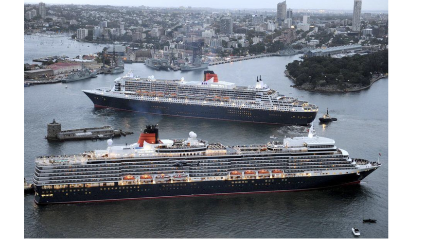
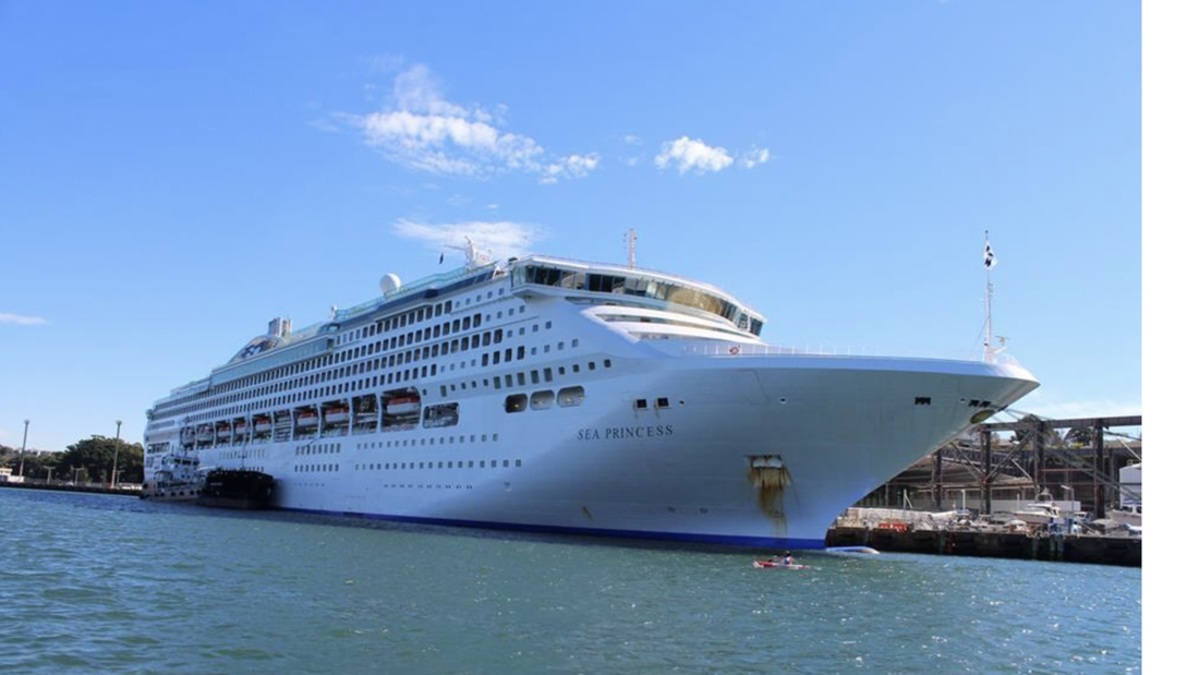
The scenic quality has been recognised as a key aspect of the cultural heritage of Sydney Harbour. This is now under threat by the growth in size and number of cruise ships occupying the eastern Harbour; however, under Neo-liberal economics, growth in tourism is seen as a key economic objective and any attempt to restrict the number of ships will be resisted.
The Momentum of Reconciliation
The recent Plan of Management for Sydney Harbour National Park seeks to increase tourist use, 3, while at the same time acknowledging the cultural heritage, stating:
"The harbour is more than a jewel – it is Sydney’s heart. Framing the waters of Sydney Harbour are its headlands and islands, bays and beaches. These special places contain a wealth of heritage resulting from the custodianship of Aboriginal people and the early phases of the harbour’s development for maritime industries, quarantine, defence and recreation. The resilience of nature and the survival of this rich heritage in such close proximity to the city is truly inspiring."
Many generations have shaped today’s Sydney Harbour National Park. Aboriginal people nurtured the landscape over millennia and continue a deep connection to the harbour, early settlers brought their own customs and desires and sought to develop, protect and enjoy these lands. Public recreation, the military’s presence and strong public support for the land’s protection precluded the kind of intense development witnessed elsewhere along the harbour foreshores. The park has been shaped by the history of settlement. 4
Thus, putting aside the threat of huge cruise ships on the scenic quality of this cultural landscape, which is not mentioned in the Plan of Management, there is nevertheless an interesting desire to acknowledge the traditional owners of the land and water.
The National Parks and Wildlife Service has increasingly sought to identify and re-establish the Aboriginal heritage values in Australian National Parks, so it is salutary to see a Statement by the Director of the Metropolitan Local Aboriginal Land Council, Paul Morris, as the frontispiece to the 2012 Plan of Management for Sydney Harbour National Park. He states:
"Aboriginal heritage and connection to nature are inseparable from one another and need to be managed in an integrated manner across the landscape. In the management of the headlands and islands of the Sydney Harbour National Park, Aboriginal cultural values will provide an anchor point for conserving and experiencing Australia’s shared history and contributing to the momentum of reconciliation. Opportunities supporting reconnection to the land for city-based Aboriginal Australians is a major focus of the Sydney Harbour National Park Plan of Management. Sydney has a rich Aboriginal presence and heritage but these aspects of Sydney’s character have until recently been largely invisible to non-Aboriginal people. The sites and stories that are so much a part of the heritage of the park will be made more accessible with opportunities to explore Sydney’s living Aboriginal cultural heritage, past and present." (Paul Morris CEO, Metropolitan Local Aboriginal Land Council) 5
That this area of the cultural landscape has the ability to ‘provide an anchor point for conserving and experiencing Australia’s shared history and contributing to the momentum of reconciliation’ is remarkably important in terms of the continuity of landscape values going back more than 250 years; one could suggest far more important than the economy of tourist ships.
Managing Western Sydney Harbour Cultural Landscape
Meanwhile the cultural landscape of the Western Harbour is under severe threat in terms of cultural continuity, namely sustaining the Harbour as a maritime cultural landscape. There are alternatives to the current model of urban redevelopment.
In 2010, debates raged around the proposed redevelopment of a former dock, Barangaroo. The Barangaroo Development Authority described it as: "One of the most ambitious and significant waterfront projects anywhere in the world. It will transform a vacant 22 hectare industrial site into a new precinct for Sydney, with a new public Headland Park and a thriving community, residential and commercial heart...It will revive the location as a trade gateway and refocus attention on Sydney to attract new regional and global headquarters" 6
But this image of ‘Global Sydney’ is brittle. This stereotyped ‘alchemy’ of a high-rise city beside a glistening harbor and scalloped edge of beaches lacks depth and resilience.
State Government required that the development be ‘cost neutral’. It also required that a large foreshore park be established by the developers who would be compensated by a significant increase in the height and bulk of the proposed commercial towers.
The public expressed alarm at the over-development of the site but also at the lack of transparency of the approval process. A Barangaroo Action Group was formed, demanding open planning processes and that commercial consideration not outweigh environmental factors; escalating public protests resulted in some modification of the scale with the developer slightly reducing the mass of the first three giant office towers.
In all the debates, the focus has been on scale, parkland, CBD commercial activities and tourism, including a landmark high-rise hotel hovering over the harbour. There has been little mention of the cultural heritage value of Sydney Harbour continuing as a ‘working harbour’ except for one of the champions of the foreshore park, former Prime Minister Paul Keating, who stated that Sydney Harbour was no longer a ‘working harbour’.
Nevertheless, some degree of compromise was reached by removing the hotel over the water, thus re-instating the sunlight and views from Darling Harbour. This, however, was short-lived. Recently the government allowed a media tycoon to lease some of the Barangaroo land designated as public open space to build a major casino. This building will be taller than any in Sydney and has flouted any planning constraints. Under these political conditions, there is little interest in the heritage associated with Sydney Harbour as a maritime working harbour.
There are however, alternatives to Late Capitalism’s model for post-industrial urban change; in this case ways to introduce innovations that can sustain industrial waterfronts as 21st century working waterways.
For example, immediately west of the Barangaroo development, there is a collection of bays, known as the Bays Precinct, that could provide different answers to the redevelopment of abandoned industrial foreshore land.
This Precinct is a diverse area, including fading maritime uses, extensive disused railway land and associated silos, and a large derelict Power Station. Although dirty and abandoned, nevertheless there are particular qualities in this marginal landscape that are worthy of respect. In this site lies the post-industrial enigma; namely, finding the way to re-engage with such places that will evoke a sense of continuity with their former industrial uses but now with new and innovative industries for the evolving 21st century. The State Government intends to extend the CBD into the Bays Precinct as part of Sydney’s continued push for global city status.
Bays Precinct presents an exceptional opportunity to strategically review a large expanse of land under NSW Government ownership, close to the Sydney CBD. Once Barangaroo is developed, Bays Precinct will offer the only remaining opportunity for significant expansion of the Sydney CBD, furthering its role as a global city in the Asia Pacific region. 7
In contrast, a Community Reference Group has developed a master plan for the precinct which states: "Our vision for the area includes open space and sports ovals, new commercial centres and mixed income housing. We envisage reuse of heritage assets, notably the White Bay Power Station, for work, for cultural enrichment and recreation, with theatres and galleries, markets and restaurants, and aim to maintain links with the past via continuing the mixed maritime activities consonant with the character of the area as a residential and service activity zone." 8
Neither of these proposals considers the Bays as sites for renewed industry building on its cultural heritage. The difference between community and government approaches will result in years of debate and protest. This delay is an opportunity to reveal the catalytic value of temporary uses including incubators for new industries within the old industrial infrastructure.
The Catalytic Value of Temporary Uses
In terms of Sydney Harbour as a heritage cultural landscape, it is worth revisiting the Barcelonan urbanist, Ignasi de Sola-Morales, who warned against expedient interventions in these residual spaces. He suggested their treatment should be undertaken within a ‘contradictory complicity’ that does not shatter the very elements which maintain their continuity in time and space. Ignasi de Sola Morales says "Only though attentive concern with continuity – not necessarily the continuity of the planned, efficient and legitimated city – but listening attentively to the flows, the energies and the rhythms which the passing of time has established." 9
Encouraged by Ignasi de Sola-Morales’ ideas, a design workshop was conducted in 2012 to explore the Bays precinct as a continuing maritime industrial place, working with his notion of contradictory complicity where designs are complicit with hidden qualities in sites as well as ambiguous in the solutions they propose. Such proposals do not remove the very elements that maintain a sense of continuity; but instead work with them; listening and reacting to the flows, energies and rhythms which have been established slowly over time.
Working within the remnant infrastructure in the area, designs were developed for new industries, particularly those that focused on environmental sustainability; such as different forms of energy, urban agriculture and methods to remove carbon dioxide from the air.
Solar Proposals
A solar energy design was proposed for Glebe Island as a huge wave-like structure, made up of hundreds of cup-like solar mirrors acting as a form of kinetic architecture, constantly changing as the solar mirrors track the sun. The energy captured in this field of shiny cups was to be directed to one of the tall silos containing salt which would become molten. A web of elevated shiny pipes would then carry this molten salt to the nearby power-station which would generate steam for turbines through the cooling process. 10
Meanwhile a kelp farm in the form of a kelp was located under the water in the bay on the west side of Glebe Island. The practicality of kelp, a fast-growing sea-weed, is that it can be farmed for bio-fuel as well as oxygenating salt water and providing habitats for small marine life. In this location, the gentle tidal motion is sufficient to generate small LED lights which at dusk will glow underwater when the mirrors cease to shine. 11 This mirrored wave in daylight echoed under water by the grid of tiny points of light at night would be a mystic diurnal ritual for all who lived nearby.
Bio-energy Proposal
Bio-Energy proposals responded as a landscape approach by using the entire Bays Precinct for phyto-remediation crops, such as hemp and bamboo, which could be harvested for bio- fuel as well as products for new industries such as textiles, paper, furniture, flooring, and construction materials. Bamboo was also intended for a bamboo boat building school which would continue the maritime history of the Bays; including traditional skills of bamboo boatbuilding, Aboriginal canoes and emerging technologies for a new maritime boat-building industry. 12
Tall bamboo, intended for construction materials, encloses the railway land much like a Chinese bamboo forest, seen from a generous boardwalk to assist with harvesting but also so that people could walk through the magic of a forest of giant bamboo. The old rail-lines transport the harvested crops to the power-station where they are used for bio-fuel and the other products; re-animating the old power-station without altering its form. 13
As a way of informing the wider community about the new industry in the bays, bamboo could be used as crop art in the form of changing sinuous curves covering Glebe Island and seen by the many people who pass over and around the site. Changing patterns of crop art will intrigue the many motorists on the bridge as they pass over Glebe Island. The different arrangements of bamboo, in wide curving planting boxes, capture wind causing the stalks to sway; thus generating energy which can be transmitted by wires to the power-station. At night small photovoltaic lights attached to the wind stalks cause them to glow, adding to the enchantment for people on the bridge and rowers in the water.
Crops of algae are also intended to produce bio-fuel for the power-station. Farms of fresh and salt water algae are terraced along the lower slopes of White Bay. Nourished by nutrients from sewage mining, as well as fresh water from street run-off and salt water from the bay, the algae are transformed into bio-oil by a process of extraction, clarification and gravity separation. The harvested algae crops are transported on the existing rail lines to the former coal-handling unit where they are stored before the distillation process.
The old power-station is a huge brick, concrete and rusted steel structure whose two tall chimneys dominate the skyline. The complex of Turbine Hall, Coal Handling Unit with its angled conveyor belt within a rusty iron casing, Boiler House, Switch House and Control Room create a landmark. The long eastern wall of giant Boiler House, four storey high, is a forbidding presence as one drives westward over Anzac Bridge. Apart from the two rusty steel stacks, this is what most people see.
The Bio-Energy proposal uses all the power house structures to convert bio-fuels of algae and bamboo into energy with little change to the complex, apart from a bamboo lattice-like addition covering the Boiler House wall. 14. This delicate scaffolding is a storage structure for electric engines suitable for small electric cars, developed as a new industry within the complex.
Urban Agriculture Proposal
‘Light’ and ‘dark’ agriculture processes were proposed for the Bays. The ‘light’ concept used the hardstand on Glebe Island as a platform for an urban orchard under a giant transparent glasshouse and as the footings for four translucent towers of hydroponic perishables.
The proposed glasshouse is a sinuous glazed space-frame over a sub-tropical and citrus orchard assisted by the old silos which would become a complex system of water purification using recycling water, as well as sites for storage of produce and mulch. Protected from salt- laden winds, the citrus orchard of orange, lemon, lime and mandarin trees and the subtropical fruit trees, mangoes, pomegranate, macadamias and avocados, are grown. Surrounding the glasshouse, is a shrubby wind-blown embankment of hardy bush-food. 15
‘Dark’ agriculture is hidden in the nondescript maritime shed. This mysterious shed encloses layers of agriculture systems needing less and less light; on top, a system known as valcent vertical hydroponic takes advantage of roof lighting, below this are omega carousel gardens with internal lighting, and below this commercial mushroom farms in the dark.
Valcent hydroponic-farming consists of stacks of trays, as lettuce, strawberries, or basil under overhead roof lighting, the stacked trays rotate on a conveyor belt system. The rotation gives the plants the precise amount of light they need, while the vertical stacking enables the use of far less water and nutrients than conventional farming.
In contrast, the Omega Carousel gardens on the level below fit into dark unlit container-like spaces. These gardens are made up of a pulley system which rotates six open tubes, at the base of which is a tray of water and nutrients. Each tube is made up of long ribs containing rows of small seedlings on the inner side of the long cylinder. In the centre of each tube is a set of long lights. As an innovative industry for urban agriculture, both the Valcent vertical gardens and the Omega carousel gardens occupy a fraction of the space normally required to produce the same amount of perishables.16
As an associated small industry, efficient modules that could distribute the produce by ferries, heavy and light rail were designed to be manufactured on site. Thus the entire Bays Precinct could be involved in agricultural production and distribution, with the old Power Station acting as a packaging and marketing centre.
Bays for New Maritime Industries
Although shipping containers have resulted in ports becoming remote from urban waterfronts, there is still the need for working wharves beside rivers and harbours within cities. The challenge of concerns about carbon as well as innovative new maritime industries have much potential to keep maritime industries viable. Inspired by the Tunnel Algal Park 17 proposal from Brooklyn to Manhattan in New York City, a new maritime industry, floating algal production pods, was proposed for the Bays Precinct. The Tunnel Algal Park in New York City is intended to be a new form of infrastructure linked with the ventilation system of underwater vehicular tunnels.
The proposal for the Bays was the manufacture of small mobile pods that could move around the Harbour pausing over carbon emission sources such as vehicular tunnels. They could also be used in any water bodies, included those associated with existing power stations. Based on bio-mimicry, the pods resemble a floating flower whose petals rotate to capture solar energy.
Under the water, wave and tidal energy is harnessed so that the pods are self-propelled as they move around the harbour to areas of high concentrations of CO2. At these sites, the inner faces of alternate solar petals covered with algal production tubes, actively absorb CO2 resulting in rapid algal growth which fills the tubes. The pods with their full green tubes return to Glebe Island where the algae are sucked out and transferred as bio-fuel for the power- station. This would augment the large algal farms created on all the existing hardstand as wide shallow pools. 18
The entire Glebe Island was intended to be redeveloped for this new maritime industry. This could be a showcase of a working port for the future. The revitalized power-station could accept the algal harvests generated by the pods and retrieved at the specially designed docking station. The existing conveyor belt conveys the algae to pyrolysis machines in the Turbine Hall where it is converted into bio-oil and bio-char. 19
Using Contradictory Complicity
The heritage of industrial sites is not maintained when derelict heritage buildings are converted into some other use such as art galleries or museums within the old shell of the building; although this is the most common re-use.
Instead, all the proposals for the Bays Precinct draw from de Sola-Morales concept of contradictorily complicity 20 where they all showed attentive concern for the continuity of former uses. For example, new forms of energy are to be processed within the original power station while maintaining its existing form and infrastructure. Solar energy from the mirror field, using molten salt technology, reactivates both the old silos and the power station.
Instead of coal, bio-fuels - bamboo and hemp from the railway land plantations and algae from the algal farms - are processed within the power-station. As well, bio-fuel from algae harvested from the floating pods re-activate the power station with minimal change to its external form. Internally, the new infrastructure is located easily beside the old internal infrastructure. All these proposals maintain the flows and rhythms of the time-worn infrastructure.
Exploring Flexibility through Temporary Projects
All of the proposals were designed in ways that allow for their dismantling and re-assembly elsewhere. The old powerhouse and the silos are protected heritage, but instead of the inevitable galleries and cultural centres, proposals re-activate their former uses, generating power and storage, relevant to 21st century needs. The phyto-remediation crops, doubling as bio-fuel, are proposed as staged plantings which allowed for an unspecified subsequent use for the precinct. Most of the maritime and rail infrastructure is maintained and reused. The ingenious use of the large maritime shed as internal agriculture was designed entirely in relocatable modules.
Conclusion
Can the cultural heritage landscapes of Sydney Harbour survive? While it is recognised that the impact on heritage landscapes by tourism involves both the tourism infrastructure and the shallow stereotypic meanings, in the case of the eastern harbour cultural heritage landscape, the most damaging aspect of the cruisers is their impact on the scenic amenity of the harbour as a public open space. There will be few times when there are not at least two and more commonly four huge boats occupying the water area of the Harbour and intruding into the quality of the Foreshore National Park all year round.
This is an aspect of limits of acceptable change which has been considered by HUL; however without World Heritage Status and the political will, it would be a challenge to control the cruising industry. Nevertheless, the outstanding significance of the national park’s role in the momentum of reconciliation may be able to control the use of the eastern harbour for berthing cruise ships and limit their size to only those that can be berthed in the western harbour.
The disruption of the continuity of a maritime working harbour is more difficult to address. Without World Heritage Listing, there is no leverage to negotiate with powerful politicians and international businesses who see the Global City model as an imperative.
Endnotes
1.Michael Collins , ‘Legacy of the docks’ in The Guardian, Wednesday 5 August 2009 http://www.guardian.co.uk/ and The London Docklands Development Corporation (LDDC), 1981-1991: A Perspective on the Management of Urban Regeneration by Taner Oc and Steven Tiesdell in The Town Planning Review Vol. 62, No. 3 (Jul., 1991), pp. 311-330 Liverpool University Press
2. Shirley Fitzgerald ‘ History of Millers Point’
3. NSW Office of Environment and Heritage, Plan of Management Sydney Harbour National Park , December 2012, Sydney: AGPS
4. ibid, Foreword.
5 ibid, Statement on behalf of the Metropolitan Local Aboriginal Land Council
6 Barangaroo Webpage http://www.barangaroo.com/opportunities.cfm?menu_id=2; Barangaroo Action Group http://barangarooaction.com.au/Default.htm; Matthew Moore, ‘Barangaroo developer unveils plan’ Sydney Morning Herald, 11 Nov, 2010www.smh.com.au
7. The Bays Precinct Background Paper, prepared by NSW Government and SHFA 8. The Future of the Bays Precinct, Sydney, prepared by CRG, March 2010
9. Ignasi de Sola-Morales, Ignasi, ‘Terrain Vagues’, in Quaderns 212 Tierra-Agua. (Barcelona: Collegio de Arquitectos de Catalunya, 1996)34- 44.
10. Proposal for Solar Field by Michelle Lan, Master Class, University of Sydney 2010
11. Proposal for Kelp Farm by Doreen Khun, Master Class, University of Sydney 2010
12. Proposal for Bamboo Boat School by John Zhao, Master Class, University of Sydney 2010
13 proposal for Bamboo Plantation and Power Station by Bella Pescia, Master Class, University of Sydney 2010
14. Proposal for bio-fuel, algal fields and Power Station modification, Master Class, University of Sydney 2010
15. Proposal for ‘Light’ agriculture by Max Milosev, Master Class, University of Sydney 2010
16. Proposal for ‘Dark’ agriculture by Kate Devine, Master Class, University of Sydney 2010
17. http://portarchitects.com/ www.portarchitects.com/project/urban-algae/
18.Proposal for maritime mobile enviro-pods by Andrew Woodward, Master Class, University of Sydney, 2010
19. Proposal for modified power station for algae as biofuel by Maria Orellana, Master Class, University of Sydney, 2010
20. De Sola-Morales, Ignasi, Differences: Topographies of Contemporary Architecture. Trans G. Thompson& S. Whiting, Cambridge, Mass: MIT Press, 1998
Bibliography
De Sola-Morales, Ignasi, ‘Terrain Vagues’, in Quaderns 212 Tierra-Agua. Barcelona: Collegio de Arquitectos de Catalunya .(1996):34-44 De Sola-Morales, Ignasi, Differences: Topographies of Contemporary Architecture. Trans Graham Thompson& Sarah Whiting Cambridge,
Mass: MIT Press, 1998
Moore, Matthew, ‘Barangaroo developer unveils plan’ SMH, 11 Nov, 2010, www.smh.com.au
NSW Office of Environment and Heritage, Plan of Management – Sydney Harbour National Park , December 2012, Sydney: OEH publishing
O’Hare, Danny, 2000, ‘Queensland Cultural Landscapes as Contested Terrains’ Volume 1, published by QUT, Brisbane
Oc, Taner and Tiesdell, Steven, The London Docklands Development Corporation (LDDC), 1981-1991: A Perspective on the Management of Urban Regeneration, in The Town Planning Review Vol. 62, No. 3 (Jul., 1991) Liverpool University Press:311-330
The Bays Precinct Background Paper, prepared by NSW Government and SHFA, 2010
© Helen Armstrong 2018